1. Woodseaves Cutting
South from the Wharf, is Woodseaves Cutting, the longest cutting on any canal in Britain at just under 3km. The sides are up to 21 metres deep. It is now a Site of Special Scientific Interest for its geological interest.
This leisurely walk is 5km, to Market Drayton and back, following the route of the Shropshire Union Canal. See locks, embankments and cuttings on the last canal designed by Thomas Telford.
Market Drayton’s canal, now part of the ‘Shropshire Union Main Line’ was the country’s last trunk canal.
Engineered by Thomas Telford, it was completed in 1835, a year after Telford’s death and just two years before the railway from Liverpool and Manchester to Birmingham was opened a few miles to the east.
Reasonable, but sometimes muddy in the cutting. Not suitable for cycling.
Use postcode TF9 2AH. Please do not park in the area reserved for long-term moorers.
South from the Wharf, is Woodseaves Cutting, the longest cutting on any canal in Britain at just under 3km. The sides are up to 21 metres deep. It is now a Site of Special Scientific Interest for its geological interest.
As you turn to the North, the wharf buildings you can see were erected by the Twemlow family of Peatswood Hall shortly after the canal was opened.
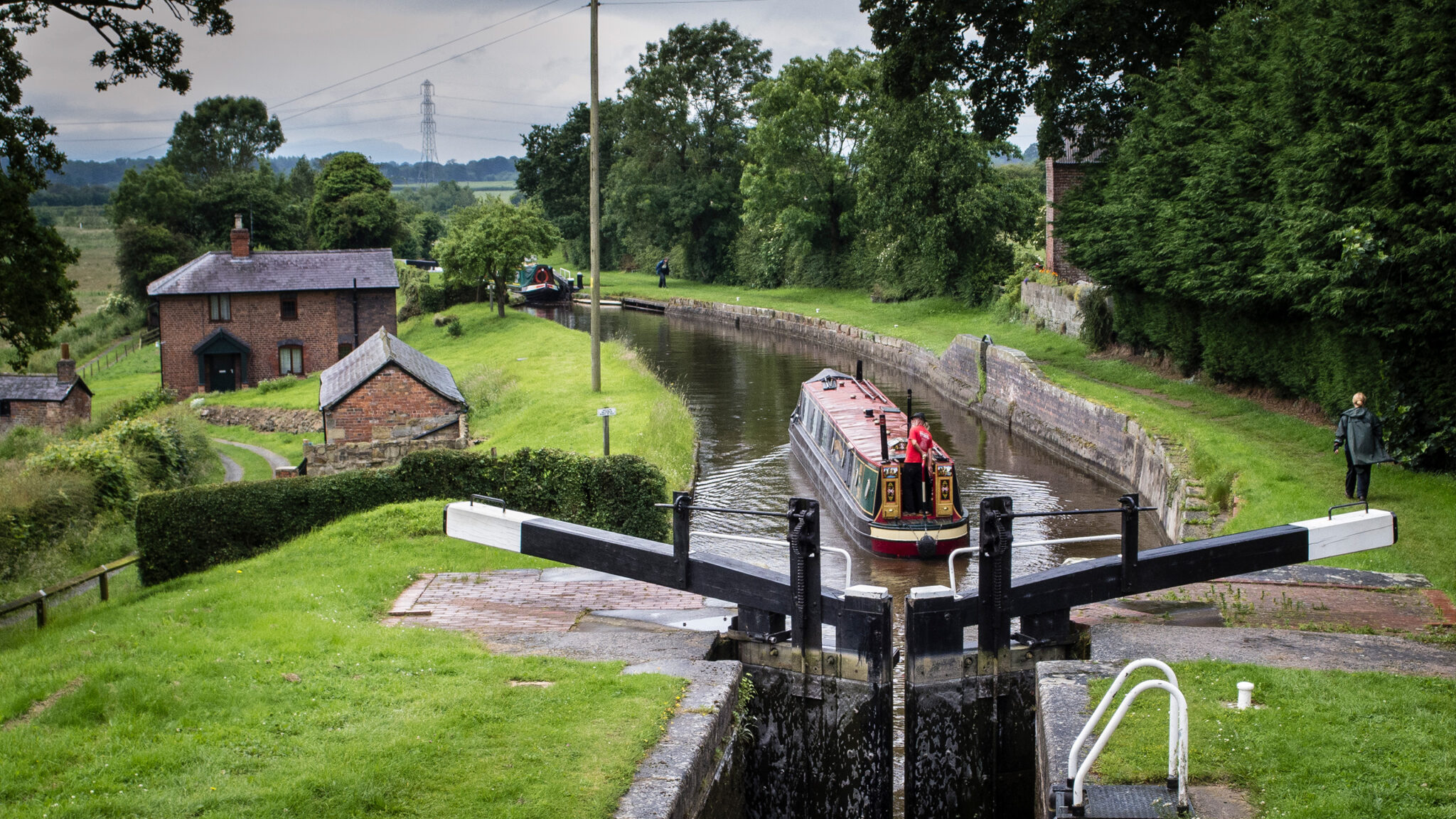
Head North along the canal and after about 200 metres you will reach the Tyrley Flight. The flight of five locks lowers the canal by 10 meters. The lock cottage is typical of Telford’s designs.
Have a look at the stonework on the far side by the top gate of the locks. Can you detect that originally there was a pair of gates here, rather than the single gate there is now?
Between the second and third lock down, on the other side of the canal to the towpath, are a couple of short posts made of cast iron with the letters ‘SUC’. These are boundary markers, showing the extent of the canal company’s property.
At the bottom of the flight you will see a bridge. This bridge has the date ‘1829’ inscribed, although the canal did not open until 1835. It is typical of Telford’s designs; the stonework curves satisfyingly in every dimension. Shortly afterwards, on the far side of the canal, is a brick-built wharf where coal was unloaded for Peatswood House.
Follow the canal over the Coal Brook, Berrisford Road and the river Tern. The steep-sided embankment is about 450 meters long and up to 15 meters high. Where the canal crosses Berrisford Road there you will see a flight of steps showing 170 years of wear. In the Second World War, pill boxes were built in strategic locations; there is one just by the bridge under the former turnpike road to Newcastle.
Beyond the bridge is the main town wharf, part used for coal and part for general goods. It was known as ‘Old Wharf’ or ‘Talbot Wharf’ (after a now-closed pub).
Continue to the next bridge and you will see Betton Mill to the right. The Mill was originally built as a warehouse in about 1905 by James Henry Jones, a corn merchant, but is now mainly apartments.
North of Betton Road Bridge were the headquarters premises of Ladyline, one of the country’s most successful canal firms in the 1960s and 1970s. From here you are about half a mile from Market Drayton town centre if you want to see the area, or you can return along the canal to complete the walk.
Download a handy one page guide to the route including a map.
(1.64MB)
DownloadHundreds of miles of waterways – along with their unique heritage and habitats – are currently starved of funding and rely on constant lobbying by us to safeguard their future.
We want boating on canals and rivers to be more sustainable and – even though the current overall contribution to UK carbon emissions is very small – we want to help reduce emissions on the waterways.
Britain’s canals and rivers are a unique, living heritage. But that heritage is at risk – from urban development, lack of protection, loss of skills and knowledge and climate change.
You can help Save Waterways Heritage.
Restoring the UK’s blue infrastructure – our inherited network of navigable canals and rivers – is good for people and places.
Britain's waterways are vital; together we can campaign for them now and for the future.
| Cookie | Duration | Description |
|---|---|---|
| __stripe_mid | 1 year | Stripe sets this cookie to process payments. |
| __stripe_sid | 30 minutes | Stripe sets this cookie to process payments. |
| cookielawinfo-checkbox-advertisement | 1 year | Set by the GDPR Cookie Consent plugin, this cookie records the user consent for the cookies in the "Advertisement" category. |
| cookielawinfo-checkbox-analytics | 1 year | Set by the GDPR Cookie Consent plugin, this cookie records the user consent for the cookies in the "Analytics" category. |
| cookielawinfo-checkbox-functional | 1 year | The GDPR Cookie Consent plugin sets the cookie to record the user consent for the cookies in the category "Functional". |
| cookielawinfo-checkbox-necessary | 1 year | Set by the GDPR Cookie Consent plugin, this cookie records the user consent for the cookies in the "Necessary" category. |
| cookielawinfo-checkbox-others | 1 year | Set by the GDPR Cookie Consent plugin, this cookie stores user consent for cookies in the category "Others". |
| cookielawinfo-checkbox-performance | 1 year | Set by the GDPR Cookie Consent plugin, this cookie stores the user consent for cookies in the category "Performance". |
| CookieLawInfoConsent | 1 year | CookieYes sets this cookie to record the default button state of the corresponding category and the status of CCPA. It works only in coordination with the primary cookie. |
| PHPSESSID | session | This cookie is native to PHP applications. The cookie stores and identifies a user's unique session ID to manage user sessions on the website. The cookie is a session cookie and will be deleted when all the browser windows are closed. |
| Cookie | Duration | Description |
|---|---|---|
| _fbp | 3 months | Facebook sets this cookie to display advertisements when either on Facebook or on a digital platform powered by Facebook advertising after visiting the website. |
| _ga | 1 year 1 month 4 days | Google Analytics sets this cookie to calculate visitor, session and campaign data and track site usage for the site's analytics report. The cookie stores information anonymously and assigns a randomly generated number to recognise unique visitors. |
| _ga_* | 1 year 1 month 4 days | Google Analytics sets this cookie to store and count page views. |
| _gat_gtag_UA_* | 1 minute | Google Analytics sets this cookie to store a unique user ID. |
| _gat_UA-* | 1 minute | Google Analytics sets this cookie for user behaviour tracking.n |
| _gid | 1 day | Google Analytics sets this cookie to store information on how visitors use a website while also creating an analytics report of the website's performance. Some of the collected data includes the number of visitors, their source, and the pages they visit anonymously. |
| CONSENT | 2 years | YouTube sets this cookie via embedded YouTube videos and registers anonymous statistical data. |
| Cookie | Duration | Description |
|---|---|---|
| test_cookie | 15 minutes | doubleclick.net sets this cookie to determine if the user's browser supports cookies. |
| VISITOR_INFO1_LIVE | 5 months 27 days | YouTube sets this cookie to measure bandwidth, determining whether the user gets the new or old player interface. |
| YSC | session | Youtube sets this cookie to track the views of embedded videos on Youtube pages. |
| yt-remote-connected-devices | never | YouTube sets this cookie to store the user's video preferences using embedded YouTube videos. |
| yt-remote-device-id | never | YouTube sets this cookie to store the user's video preferences using embedded YouTube videos. |
| yt.innertube::nextId | never | YouTube sets this cookie to register a unique ID to store data on what videos from YouTube the user has seen. |
| yt.innertube::requests | never | YouTube sets this cookie to register a unique ID to store data on what videos from YouTube the user has seen. |